


The US-Canada border is weird
More so than you probably think


Last week I wrote all about some of the more bizarre borders in the world and why they exist. But while that was a fun video and article to write, it spawned out of my fascination of the US-Canada border. You see, while the US-Canada border looks pretty ordinary, there’s actually tons of weird little bits to it that make it a fascinating study in why borders are, by and large, kind of weird. So why is it so weird? Glad you asked!
But first, let’s talk about the physical geography of where the border goes.
The geography of the border
At 5,525 miles (8,891 kilometers), the US-Canada border holds the distinction of being the longest international border in the world. Now, you’d think that a border between two friendly nations would be relatively straightforward, right? I mean, an incredibly long portion of it is, in fact, a straight line. But it’s not! In fact, the US-Canada border is one of the most fascinatingly complex borders on the planet. Mostly due to a series of treaties that had awfully vague language attached to them.
Overall, US-Canada border spans the North American continent, crossing a wide variety of different landscapes (duh). It begins (chronologically speaking) on the Atlantic coast between Maine and New Brunswick, winding through dense forests and rugged highlands. It then dips south along the 45th parallel, eventually following the waterways of the Great Lakes, including the iconic Niagara River and the Thousand Islands.
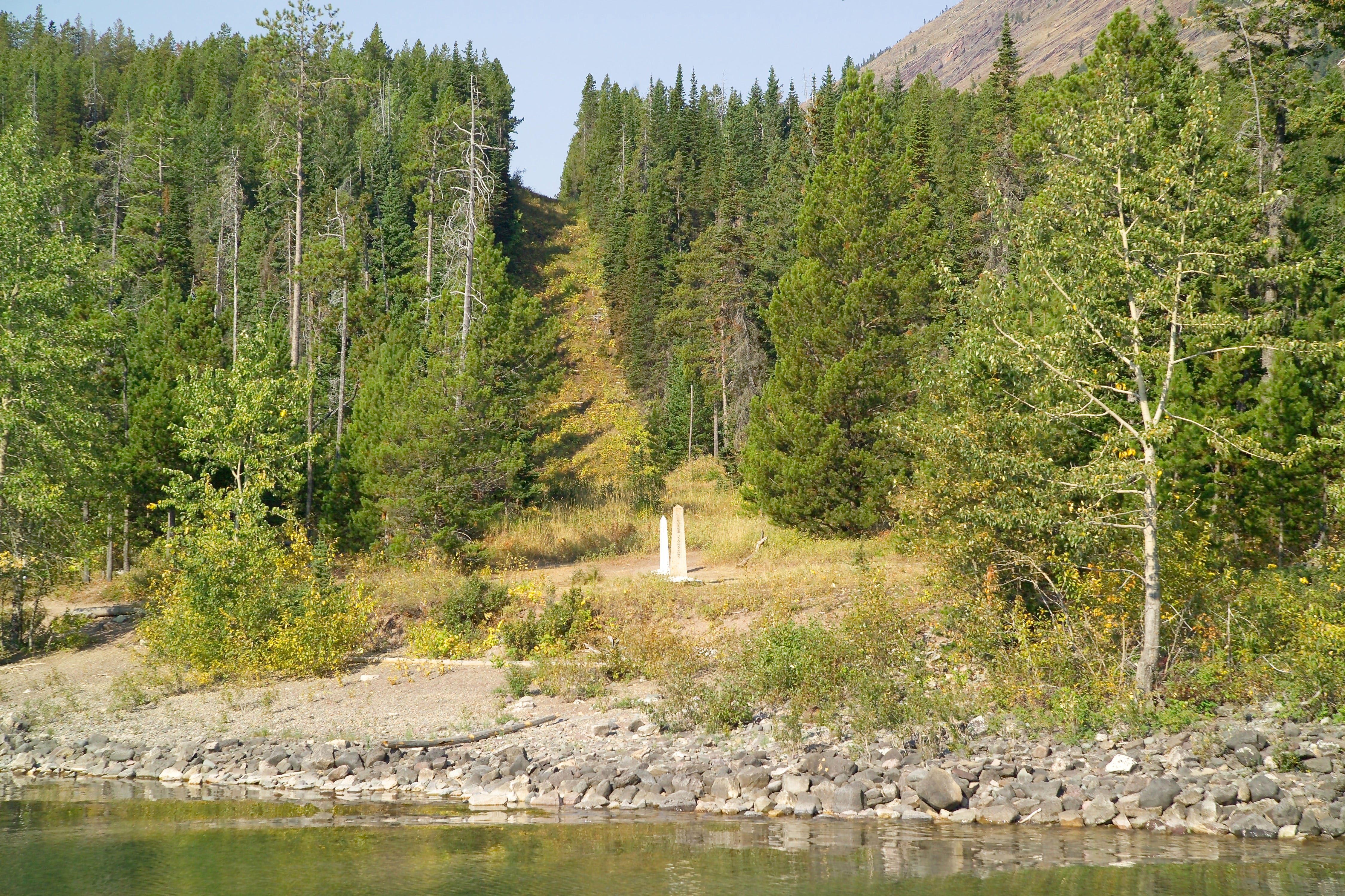
From there, it follows the Pigeon River, traversing dozens of smaller lakes, including the infamous Lake of the Woods. This area includes one of the border’s most peculiar features, which we’ll cover. West of Lake of the Woods, the border stretches along the 49th parallel, cutting across vast farmlands and meandering rivers like the Red River of the North. As it approaches the Rocky Mountains, the landscape becomes more dramatic, with rugged peaks and alpine forests forming the boundary. Glacier National Park in Montana and Waterton Lakes National Park in Alberta straddle the border, creating one of its most picturesque sections.
Moving further west, the border passes through the temperate rainforests and mountain ranges of British Columbia and Washington, reaching the Pacific Ocean near the Strait of Juan de Fuca. Meanwhile, in the north, Alaska’s border with Canada follows natural features such as the Yukon River and the towering St. Elias Mountains.
Now that we’ve traced the border’s geography, let’s explore its quirks.
Quirks of the US-Canada border
The US-Canada border is a logistical marvel, with its incredible length requiring multiple staffed crossing points. And ,remarkably, it remains undefended militarily. That said, it is dotted with little peculiarities.
Now, this is just a smattering of weird bits. There’s more to point out, but I wanted to focus on these little border quirks because they’re things that most people don’t really know. And even if you know one or two, it’s doubtful you know that these weird spots exist all along the border from Maine to Alaska.
We’re going to start with the big spots and work our way down.
The 49th Parallel
Obviously this is the largest section of “weird” that exists along the border. Because, if you didn’t notice, a really long portion of the border follows the 49th parallel, a latitude line dividing the two countries for about 1,260 miles. This straight boundary slices through forests, creating visible clearings. From the Strait of Georgia in the west to the Lake of the Woods in the east, this is just a straight line. But while that’s certainly a odd part of the border, perhaps the odder bit is that the 49th parallel doesn’t continue until it hits the Great Lakes. Instead, the border dips south along the Pigeon River for the last 300 or so miles. This is due to the original 1783 Treaty of Paris which created the United States. You see, back in the late 1700s, nobody really knew where anything was in this whole region at the time. They knew there was a river in the general location and marked the border to it, but where that river led was another question entirely!
And this leads us to another really weird part of the border.
The Northwest Angle

Nestled at the northernmost point of the contiguous United States, the Northwest Angle is a small patch of land, known locally as "the Angle." And while it penetrates into Canada, it is actually part of Minnesota.
This weird push into Canada is due to the very same inaccurate maps that were used to define the boundary between the newly formed United States and British-controlled Canada. According to the treaty, the boundary was supposed to follow the Mississippi River to its source and then proceed westward. However, early maps mistakenly extended the Mississippi much farther north than it actually reaches. When the true geography of the region was discovered, it left this isolated pocket of U.S. territory hanging above the 49th parallel, surrounded on three sides by Canada.
Today, the Northwest Angle is home to fewer than 100 residents, most of whom live in a small community near Angle Inlet. Accessible only by boat, by crossing the frozen lake in winter, or by driving through Manitoba, Canada, the Angle’s isolation has created a lifestyle that’s both remote and uniquely tied to cross-border cooperation. Residents frequently travel through Canada to access basic services, and visitors to the Angle must check in at a remote U.S. Customs phone booth to declare their entry.
Now if you think the Northwest Angle is weird, let’s go to another oddball piece of land that should probably belong to Canada.
Point Roberts

Located just south of Vancouver, British Columbia, is a tiny peninsula that is owned by the United States with a similarly unique geographic story. This small community exists, once again, because of a treaty that didn’t quite understand the land. The 1846 Oregon Treaty, which set the boundary between the United States and British Canada at the 49th parallel, inadvertently sliced through the Tsawwassen Peninsula, leaving the southern tip—a mere five square miles—as part of the United States.
Point Roberts’ location, of course, means that it is entirely cut off from the rest of Washington state, accessible by land only through Canada. Residents must cross two international borders just to travel to mainland Washington for school, work, or shopping. This daily border crossing has created a lifestyle intertwined with both Canadian and American systems.
Despite its isolation, Point Roberts thrives as a small, tight-knit community. Its unique position has also given rise to some unusual dynamics. Many residents work in nearby Vancouver but maintain U.S. residency for visa or tax reasons. Similarly, Canadians often purchase property in Point Roberts as vacation homes, attracted by the area’s picturesque setting and proximity to Vancouver.
With the bigger spots out of the way, let’s get to my very favorite oddities along the border!
Derby Line, Vermont

Did you know that a US town is split by the border? It’s Derby Line Vermont! This small town is famously split by the international boundary, with the border cutting through buildings like the Haskell Free Library and Opera House. Built in the early 1900s as a symbol of friendship, the library’s front door is in the US, while its reading room lies in Canada. Similarly, some private homes are bisected by the border, meaning residents might eat breakfast in one country and sleep in another.
Now, all that said, while this seems like an area that might exist outside of normal border rules the unfortunate reality is that it still has to adhere to them. After 9/11, border security became much more rigid and now people visiting the town must go through an actual checkpoint down the street if they wish to enter either Canada or the United States.
The road that crosses the border

Now despite border checkpoints still being a thing, there is one place where you can drive into Canada without having to go through customs! East Richford Road in Vermont briefly crosses into Canada before looping back into the US. Unlike most border crossings, no customs checkpoint exists here. That said, the road’s detour only takes you about 550 feet into Canadian territory and there’s literally no way to drive further into the country. So it’s merely a symbolic visit to Canada. But, if you wanted to say you were in Canada but didn’t want to go through all the customs and border patrol hassle, you can technically do it here!
One thing I’m uncertain on here is how international laws play out in such a scenario. I wonder if anything has ever even happened to necessitate anyone even finding out! 🤔
Hyder, Alaska

Up in Alaska there exists a town that is only accessible by land from Canada! This means that the town of Hyder is heavily reliant on the nearby Canadian town of Stewart, British Columbia. In fact, Hyder residents are so ingrained in the Canadian side that residents use Canadian currency (though US dollars are also used), celebrate Canada Day, and adjust their clocks to match Pacific Time rather than Alaska Time. Hyder residents also use the British Columbia 250 area code rather than the Alaska 970. This kind of town really makes you think: if the border didn’t exist would there be any difference at all between the two towns?
The same, of course, could be said for one particular Canadian island town.
Campobello Island, New Brunswick

Over in the far east, this Canadian island is connected by road only to the US, via a bridge to Maine. This means that residents must cross the border for essentials like food and even healthcare services! Such a disconnect from mainland Canada has lead to residents calling for a direct bridge to be built to Canada. Unfortunately, such a bridge would be wildly expensive and challenging to build. Mostly because it would likely require two bridges. One first to Deer Island and then a second to mainland New Brunswick. And each of those bridges would need to be about 3 miles in length. That’s quite long for a bridge! Of course, the island does have ferries which connect to the mainland, but ferry service is inconsistent, and during winter, dangerous conditions make travel nearly impossible. Which means that residents of Campobello Island will need to rely on the United States for the foreseeable future.
Every border in the world has similar weird spots, but this one is just so interesting because, based on its otherwise pretty plain looking geography, you would assume it’s pretty simple.
Do you have another weird spot along the border that you know of, but I didn’t catch? Let me know in the comments!
Nice recap of the history of the border!
Every time I look at the Canada-US border, it makes me think that they gave up talking about the details after reaching Buffalo Point. They just agreed to The 49th Parallel and ended the conversation.
Kind of like what happened in Africa, but at least trying for a while.
Pretty darn nice. Although I did read about Roberts a while back. Alaska needs to be covered too, with its eastern border with Yukon. Season Greetings.
The Wordsmith.