


The strangest borders around the world
And how they came to be

Every line on a map has a story of how it came to be. Long time readers know that this is a topic I am particularly fascinated by! Borders are these invisible yet undeniable markers of sovereignty that determine so much of our human existence. Now, all that said, not all borders are perhaps as neatly drawn as we might think. Some are tangled webs of treaties, geography, and sheer coincidence, producing territories that defy the logic of maps. So here’s a dive into some of the world’s most bizarre borders, and the curious histories that made them possible.
And, of course, if you’d rather watch the video on these same borders you can do so here:
Baarle-Hertog: Where Belgium and the Netherlands intertwine
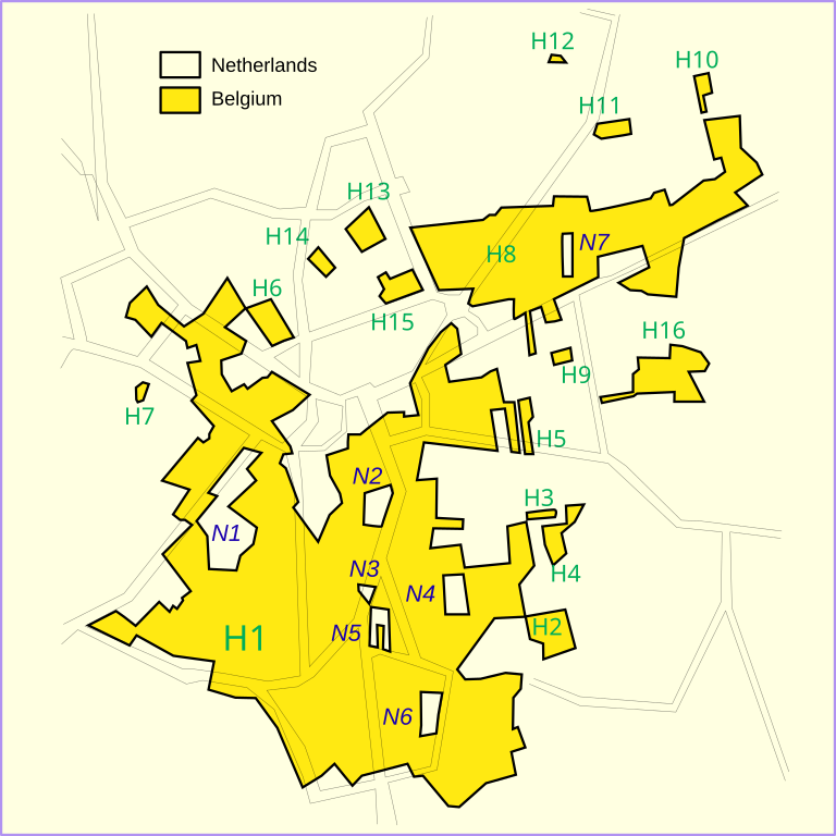
The Belgian-Dutch border might be one of the most complicated in the world, particularly in the villages of Baarle-Hertog and Baarle-Nassau. Imagine strolling down a street, entering a café in Belgium, but sitting at a table located in the Netherlands. In Baarle, some houses and businesses are split in half by the border, forcing residents to obey two sets of rules depending on which room they’re in. One half of a building may belong to Belgium, the other to the Netherlands.
This quirky situation dates back to medieval land deals between local noble families. The arrangement remained relatively unbothered until the 19th century when the region’s political landscape began to solidify into modern national borders. The result? A checkerboard of Belgian and Dutch territories that still confound visitors today. While the complex border creates some logistical challenges, it also provides a fascinating example of how historical agreements can persist into the present.
The N54: The road that crosses the border 5 times in 5 miles
The border between the Republic of Ireland and Northern Ireland is not just a physical divide but an emblem of political and sectarian tensions that have long simmered. Established in 1921, the boundary was the result of a partition between the island’s Catholic-majority south and Protestant-majority north. For decades, this border was heavily militarized, especially during the Troubles, a period of violent conflict between Catholic nationalists and Protestant unionists.
The Good Friday Agreement in 1998 brought peace and allowed for a "soft" border, facilitating free movement between the two territories. However, the arrival of Brexit reignited old concerns. To avoid a hard border on the island, the UK and the EU agreed to create a de facto customs border in the Irish Sea, a solution that has not been without its political challenges, particularly in Northern Ireland. The border’s complexity is highlighted by stretches like the N54, where the road zigzags between Ireland and Northern Ireland, creating a surreal experience for anyone trying to navigate its twists and turns.
The Neum Corridor: Bosnia and Herzegovina's tiny coastline
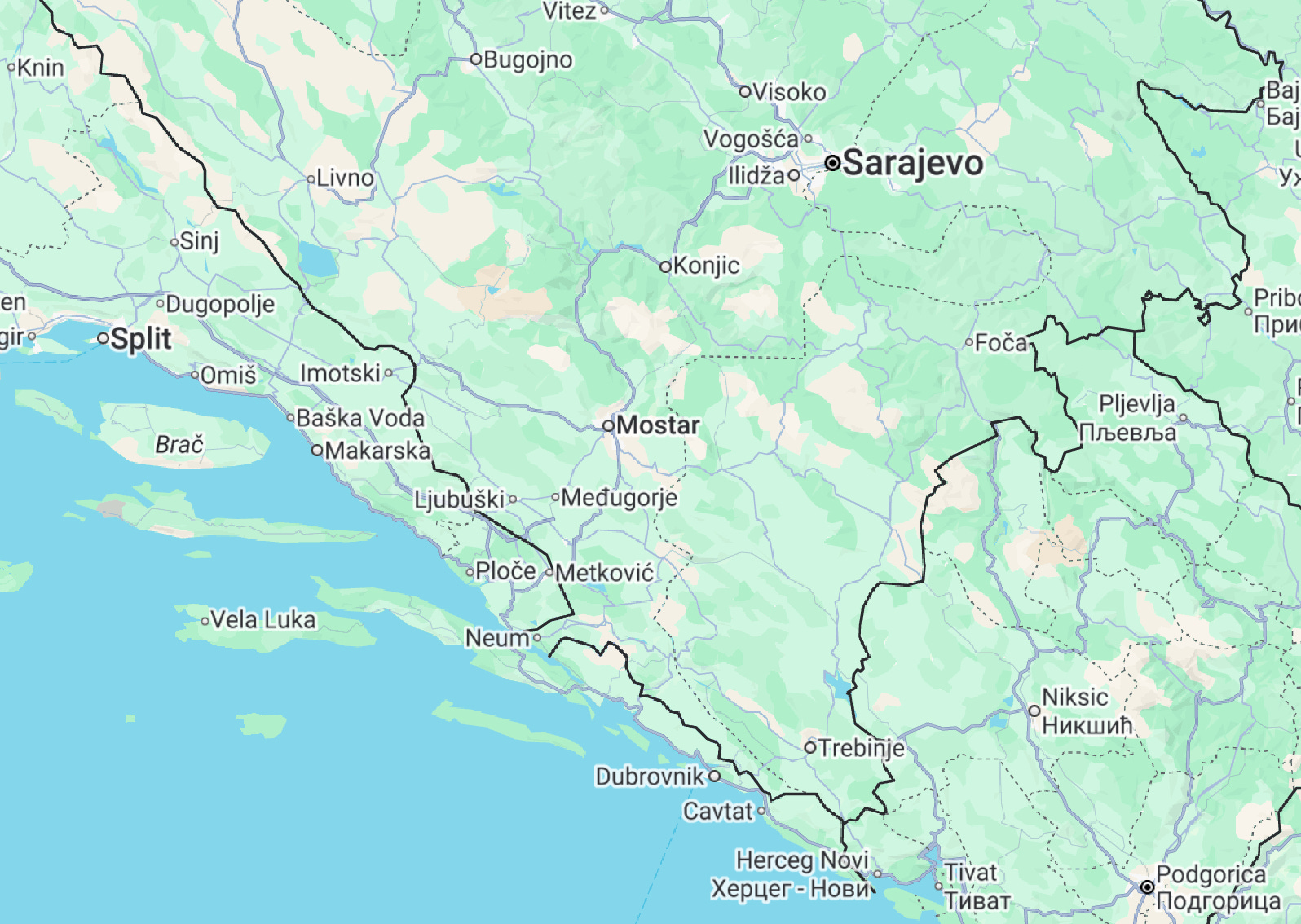
In the heart of the Adriatic, a curious sliver of land cuts through Croatia’s otherwise uninterrupted coastline. This strip of territory, known as the Neum Corridor, is Bosnia and Herzegovina’s only access to the sea. It’s not just an oddity for its shape but because it forces travelers to cross an international border to traverse Croatia. Historically, the corridor was a product of the Treaty of Karlowitz in 1699, where Bosnia secured the land to serve as a buffer between the Venetian and Ottoman empires.
While Croatia’s Pelješac Bridge now provides a workaround by connecting parts of the country without venturing through Bosnia, the Neum Corridor remains an awkward but enduring reminder of shifting empires and international negotiations.
Hala’ib Triangle and Bir Tawil: The wanted and the unwanted
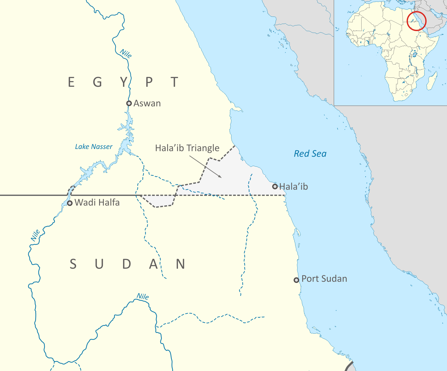
In the desert between Egypt and Sudan, two adjacent regions illustrate an odd geopolitical dilemma. The Hala’ib Triangle, a resource-rich stretch of land along the Red Sea, is fiercely contested by both nations, each claiming it as their own. Despite its scarcity of population, the area’s potential for exploitation has made it a point of contention for decades.
In an ironic twist, however, just a stone's throw away lies Bir Tawil—a stretch of uninhabitable desert that neither Egypt nor Sudan wants. This strange reverse claim occurs because the land, though barren, could jeopardize the more lucrative claim to Hala’ib. The result is that both countries have agreed to leave Bir Tawil as a desolate, unclaimed wasteland, an anomaly in the world of international boundaries.
The Gambia: One country, surrounded by another
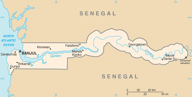
The Gambia’s borders are as weird as they are penetrative. This sliver of a country runs along the Gambia River, a thin line between Senegal to the north, south, and east, and the Atlantic Ocean to the west. Despite its small size (at its widest, it’s only about 50 kilometers wide) the Gambia is entirely encircled by Senegal, a unique and somewhat inconvenient geographical arrangement.
The border itself is a colonial relic that was drawn by the British in the 19th century with little regard for geographical or cultural cohesion. It has created tensions and logistical headaches, though today, both countries cooperate closely. The Gambia’s position within Senegal remains one of the more bizarre outcomes of colonial border-making.
Namibia’s Caprivi Strip: The accidental handle
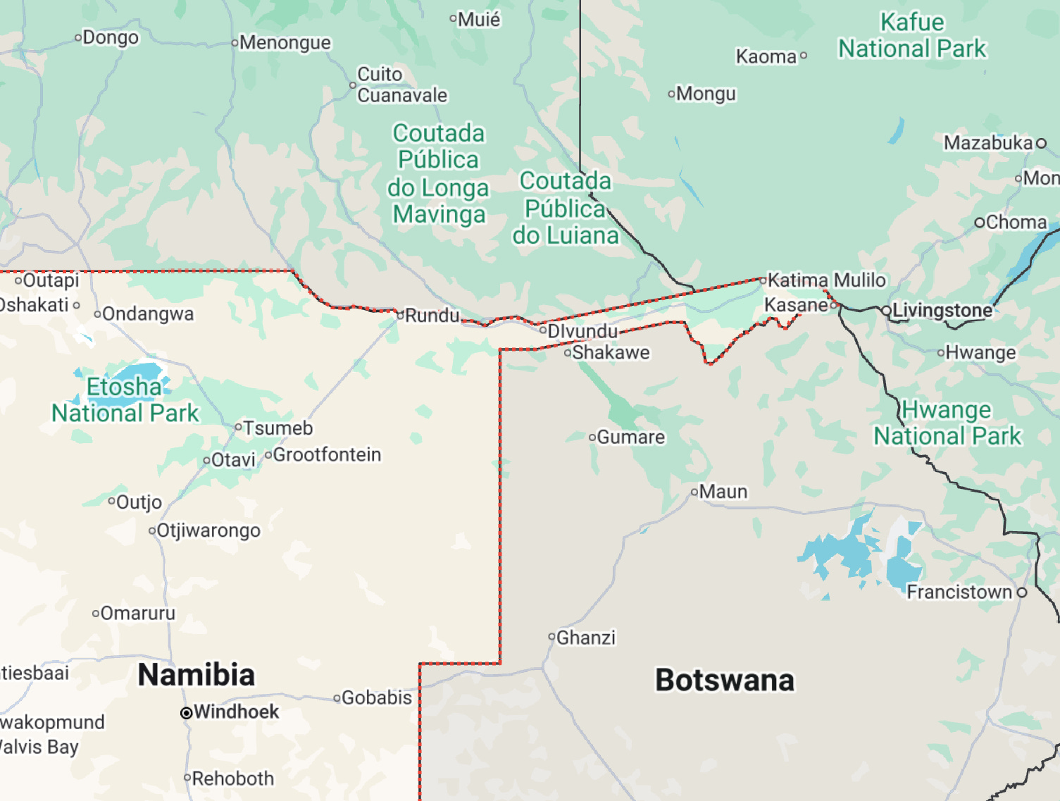
Not to be outdone by The Gambia through, In southern Africa, Namibia’s Caprivi Strip sticks out like a thumb, its long, narrow stretch of land sandwiched between Angola, Zambia, Botswana, and Zimbabwe. This “handle” extending into central Africa was the result of 19th-century European colonial ambitions. Germany, which ruled Namibia at the time, wanted access to the Zambezi River, thinking it would provide a vital link between its southern and eastern African colonies. Unfortunately, the river is impassable due to the formidable Victoria Falls, leaving the Caprivi Strip more of a geopolitical mistake than a masterstroke by Germany.
Today, the strip is a region of ecological importance, home to unique wildlife and indigenous communities, but it still presents logistical challenges for Namibia and its neighbors.
Madha and Nahwa: The exclave inception
At the border between the United Arab Emirates and Oman, the villages of Madha and Nahwa create one of the world’s most intricate border arrangements. Madha, an exclave of Oman, is entirely surrounded by the UAE, but within it lies Nahwa, an exclave of the UAE. This nested exclave situation is a political and geographical oddity, born of tribal loyalties in the early 20th century.
Though the two countries share a peaceful relationship, the intricacies of this border highlight the often-overlooked complexity of regional politics, where allegiances and tribal connections can have long-lasting implications on national boundaries.
The Fergana Valley: Kyrgyzstan, Uzbekistan, and Tajikistan’s crossroads
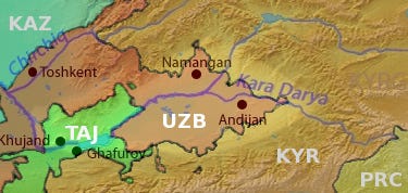
The Fergana Valley, a fertile patch of land nestled between Kyrgyzstan, Uzbekistan, and Tajikistan, is one of the most complicated border regions in the world. Within this valley lie multiple exclaves, creating a geopolitical labyrinth that has led to numerous disputes over resources and territory. These borders, drawn during Soviet times with little consideration for ethnic divisions, have created tense relationships between the three countries.
The Fergana Valley’s mish-mash of borders and exclaves highlights the lasting impact of Soviet-era decisions and the challenges of managing shared resources in a region where borders seem more like suggestions than concrete lines on a map.
Guatemala and Belize: A border dispute without resolution
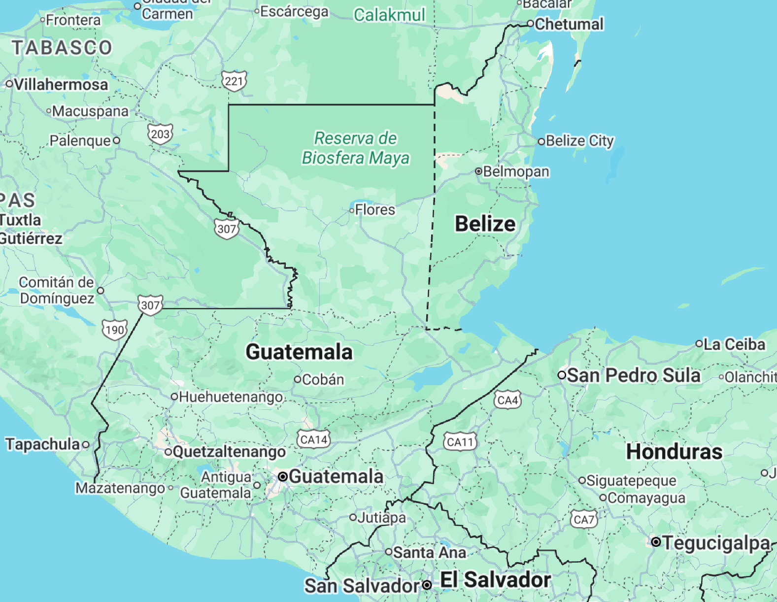
The border between Guatemala and Belize is not only weird, but also contentious! It’s one of the few borders in the world that remains disputed in its entirety. The issue dates back to the 19th century when Britain and Guatemala signed a treaty that Guatemala later argued was violated. Despite ongoing international mediation, the dispute continues today, with occasional tensions and military posturing.
Perhaps most curious is the village of Arenal, where the border bisects homes and businesses, creating confusion over where one country ends and the other begins. To this day, residents of Arenal still aren’t 100% sure where the border is located.
Essequibo: A conflict rising in South America
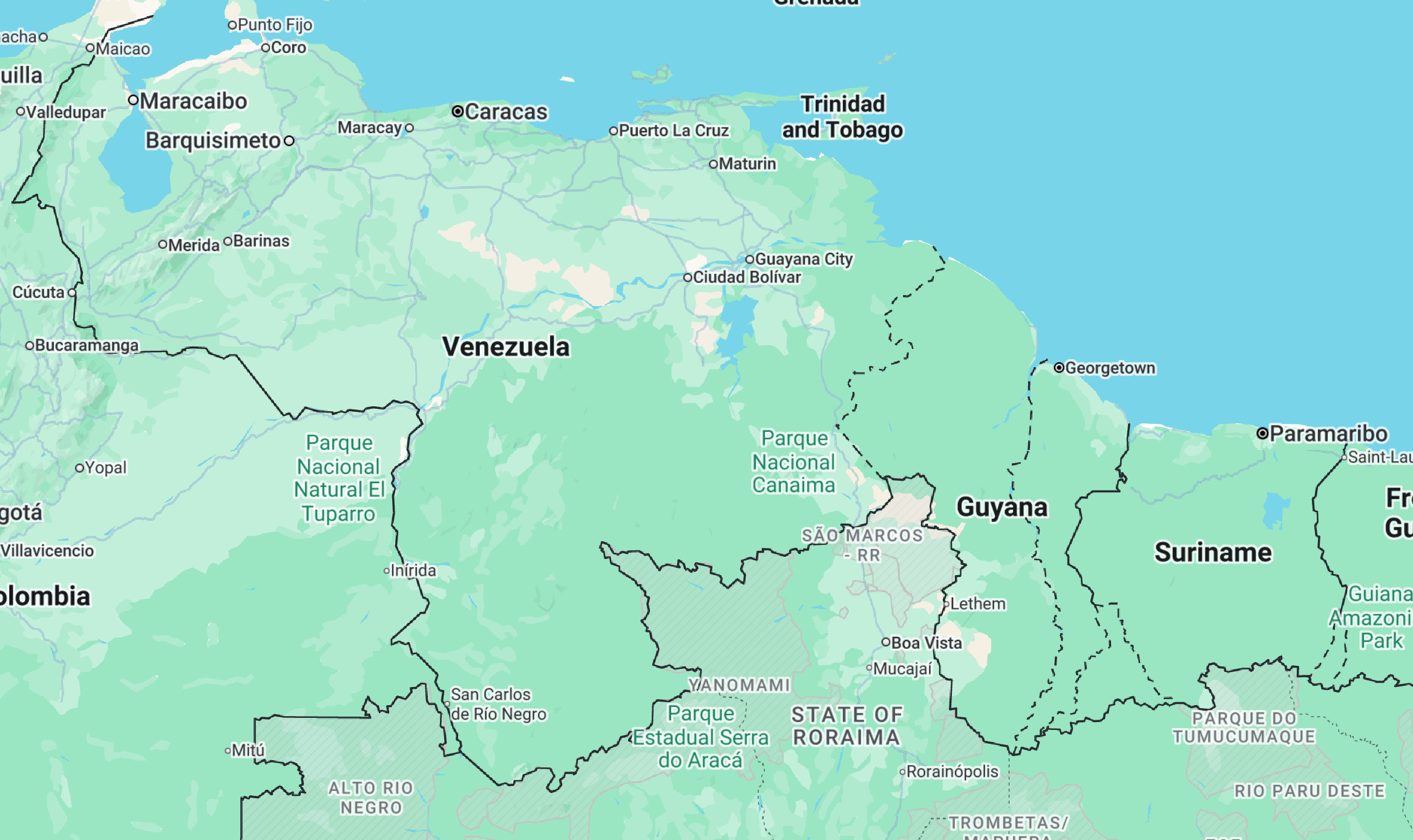
The border dispute between Venezuela and Guyana over the Essequibo region is not only one of the most significant territorial conflicts in South America, but it also involves a wealth of natural resources. This area is rich in minerals, forests, and offshore oil reserves spanning over two-thirds of Guyana. Venezuela claims the region based on a 19th-century arbitration decision that it deems unfair. Though the case is currently before the International Court of Justice, Venezuela’s refusal to accept the ruling means that the dispute remains unresolved, and tensions continue to simmer over the region’s riches.
Every border is weird to some degree
Every border has a story. And every border is weird to some degree. These are just some of my personal favorites! But there’s one border that I think is actually far weirder than anything I’ve listed here: the United States-Canada border. And I’ll be creating a whole video (and writing a whole article about it) for next week.
Until then: do you have a border you want to share? Drop it in the comments!
Interesting read, Gibson. Sincere Wishes for a brilliant New Year 2025!
The Guatemala-Belize dispute reminds me somewhat, as someone in Quebec, of the Quebec-Labrador border dispute. In this dispute, Labrador is widely understood to belong to Newfoundland (the latter's official name for over 20 years now being Newfoundland & Labrador), but Quebec claims all of Labrador for itself.