

The crazy plan to build a canal from the Columbia River to the Puget Sound
Though it was surprisingly very pragmatic for the time.


Thels. In addition to the many, many smaller canals it built throughout the country to connect people by water, it was also primarily responsible for the building of the Panama Canal. Which probably doesn’t need any sort of explanation for why that’s important to the world. Regardless, the canal I’m writing about today ultimately never materialized, but it very well could have!
Where the canal would have been built
Before we get to why a canal was proposed at all, it might be nice to shed a little light on where the canal would actually be built. Obviously, the Columbia River is a huge river that stretches all the way from British Columbia and down to the Pacific Ocean, separating the states of Washington and Oregon from each other. And while there doesn’t appear to be any modern maps of the proposed canal’s location, I did manage to find a couple older ones that basically laid out where the canal would be located and I recreated them as best as possible here:
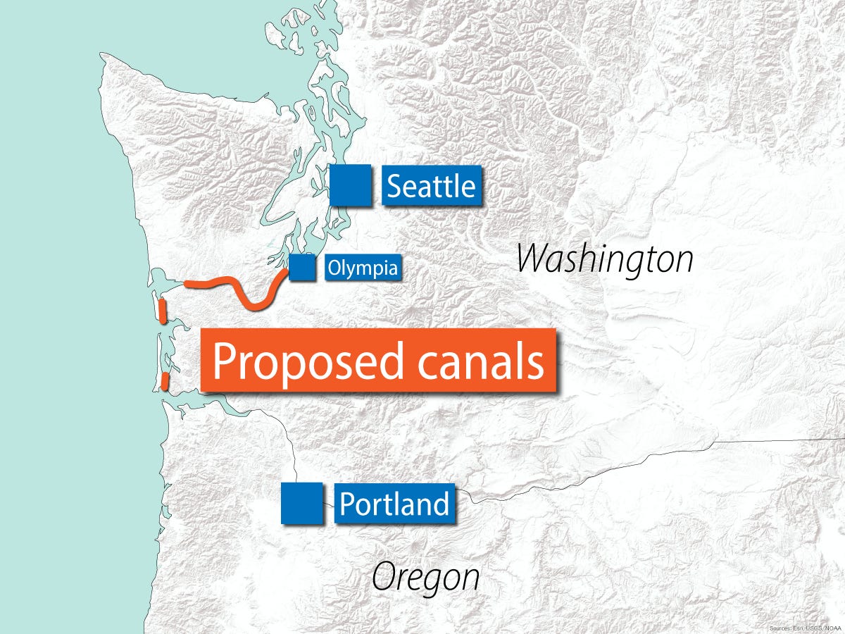
Essentially, the canal would be constructed in three parts. The first would connect from the Columbia River (near the mouth to the Pacific) to Willapa Bay just a few miles north. From there it would connect Willapa Bay to Grays Harbor about 11 miles north. And finally a third canal would be built from Grays Harbor to the Puget Sound at Olympia, the capital of Washington state. It would do so by using the Chehalis River and then building an additional 58 mile canal to connect to the Puget Sound.
The goal here was to create an inland water route all the way from Portland on the Columbia River up to the ports in Seattle, and onward north to British Columbia and southeast Alaska, cutting down on time and some logistical issues that weren’t easily solved at the time.
Why build a canal at all

The most famous canals in the world were built to solve pretty obvious logistical issues. Prior to the Panama Canal and Suez Canal being built, freight and shipping would have to travel around the tips of South America and Africa respectively to make it to their final destinations. These two canals cut down on an immense amount of time and therefore reduced the cost of shipping from Asia to Europe and the eastern shore of North America. The Pacific Northwest canal is perhaps not as obvious, but not totally without reason either.
But before we even get to the canal itself, it’s probably worth pointing out that, when it was originally proposed in the late 1800s, the largest and most dominant city for the region was not Seattle. It was Portland! And true to its name, Portland had a lot of industry flowing through it which necessitated a large port to get its goods out to the world. Back during this time, it mostly would have been agricultural products from the fertile Willamette Valley. It would take until about 1910 for Seattle to start supplanting Portland as the dominant city.
But while Portland was dominant, it turns out that getting goods in and out of the city was a huge challenge. While the Columbia River is a truly massive river, and the mouth of the river is awe-inspiring in its size, it’s quite dangerous to move in and out of. The Columbia Bar, also known as the “Graveyard of the Pacific,” is considered to be one of the most dangerous routes in the world. Since the late 1700s, over 2,000 large ships have sunk in the area. Even to this day, the U.S. Coast Guard has to guide freighters through the Columbia Bar to ensure it safely makes it to Portland. So, suffice it to say, this area was seen as quite the obstacle to the Pacific Northwest’s largest port at the time.
As such, a canal being created from Willapa Bay to the Columbia River would allow ships to pass this incredibly dangerous obstacle altogether. From there, a new canal to the Puget Sound would not only speed up interregional trading between Portland and Seattle, but also just allow for a more controlled shipping route in general. While the Olympic Peninsula is not quite as much of an obstacle as South America or Africa, the canal was still seen as a way to significantly speed up freight.
How it could have changed the region

Ultimately, the canal never materialized. Though it was still being proposed as late as the early 1970s. At that point the commission organized to study and push for the canal at the federal level, ran out of money and was disbanded. But had they succeeded, there’s a significant chance that the Pacific Northwest as we know it today, could have looked very different!
For one, while there are a myriad of reasons for Seattle’s growth over Portland, one of them was certainly the ease of getting freight in and out of the region. As rail began connecting the region, and then highways and the interstate highway system, it became cheaper and easier to move Portland goods to Seattle and ship them out of the Port of Seattle rather than have ships come through the Columbia River. This ultimately led to more jobs and a bigger economy in Seattle during the early and mid 1900s. And with more jobs and economy, more people moved to the Puget Sound region of the Willamette Valley.
Had the canal been built, however, and shipping into and out of Portland was made easier, it’s likely that Seattle and Portland would be a little more equal than they are today. Portland probably would have still lost its dominant position because, again, there were many reasons for Seattle’s ascendancy in the region, but it likely would have been less dramatic than it is today.
Regardless of the Portland-Seattle rivalry, it was estimated building just the 10 mile canal between Willapa Bay and Gray’s Harbor would have injected about $25 million into the Pacific Northwest economy if it had been built during the Great Depression years (almost $500 million today), which absolutely would have been transformational simply from an economic perspective.
In the end, no canal was ever built, and we’re left with just speculating endlessly on the ‘what ifs’ of it all. And, of course, there’s basically no chance it will ever be built today or in the future. Still, a fun slice of Pacific Northwest history!